SWITZERLAND
CATHEDRAL
|
ALL ABOUT SWITZERLAND |
|
BASEL CATHEDRAL |
|||||
Swiss Cities Basel · Minster/Cathedral · Medieval Gates · Paulus Church · St. Anthony Church · Tinguely Fountain · Bridges & Ferry · Rhine Ports · Basilisk Bern Geneva Lausanne Lucerne St. Gallen Winterthur Zurich Alpine Resorts Bernese Oberland Zermatt/Matterhorn Swiss Tour Chillon Castle Rhine Falls |
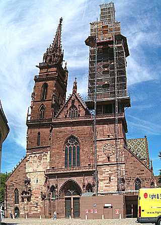
Basler Münster (Basel's Cathedral)
|
 |
Basel's medieval cathedral is situated on a hill high above river Rhine which has been inhabited even before the Age of Romans. The Romans had a fortress on this hill. The bishopric of Basel was founded in 343, his original residence was at Augusta Raurica, a large Roman military camp some miles southeast of Basel, however. In the early middle ages the bishop moved to Basel and the place served as temporary residence of the German kings - like dozens of other old cities (among them Zurich Grossmünster and St. Gallen monastery). These former royal residences are called Pfalz [from Latin: palatium = palace]. Basel's first cathedral was built by bishop Haito in the carolingian epoch (805-823). A larger building named Heinrichsmünster after German king Henry II was consecrated in 1019. Towards the end of the 11th century a tower on the west side was added - which is still part of today's Georgsturm. A new church building in late Romanic style was erected between 1220 and 1230, but almost completely destroyed during the great Basel earthquake in 1356. This building was restored using basically the same ground plan, but with some new elements in Gothic style and consecrated in 1363. Attached to the church is a former monastery. The towers were erected in 1429 (Georgsturm, northwest) and 1500 (Martinsturm, southeast). During 16th church reformation the monastery was closed down and the bishop expelled from the city. The cloister is open to the public. |
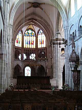 Nave |
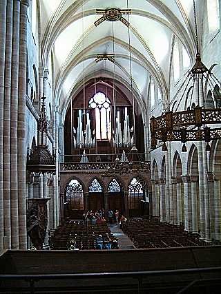 Organ |
Münsterplatz (left shore of River Rhine
between Wettsteinbrücke and Mittlere Brücke)
Trams 2, 15 to stop Kunstmuseum, then walk through Rittergasse.
Access from Mittlere Brücke / tram stop Schifflände is possible
through Rheinsprung / Augustinergasse, but a little longer and quite steep uphill.
GPS coordinates: latitude=47.556227 longitude=7.592990
map by search.ch

Short quotations allowed but with precise declaration of origin (Link).
Reproduction of substantial parts and pictures in printed or electronic form
only with explicit written consent by the editor.
| Disclaimer | Privacy Policy | www.all-about-switzerland.info © 2005-2010 All Rights Reserved | Editor | ||